
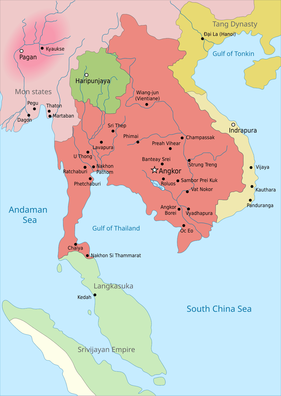
In the year 802 CE, high in the Phnom Kulen mountains, a prince named Jayavarman II declared himself universal ruler, or chakravartin, setting in motion an empire that would come to dominate mainland Southeast Asia for more than six centuries.
In the year 802 CE, on the mist-shrouded plateau of Phnom Kulen, a Khmer prince named Jayavarman II climbed the sacred slopes of Mount Mahendraparvata to perform a ritual that would break his land’s vassalage to a mysterious maritime power known in the stone steles simply as "Java." Guided by Hindu priests, the prince undertook a grandiose consecration, declaring himself not merely a regional warlord, but a chakravartin—a universal ruler, an emperor—and a devaraja, or god-king. This was the foundational act of Kambuja, the state that would come to dominate mainland Southeast Asia for over six centuries. It was a declaration of total independence and cosmological supreme authority, staged on a mountain that rose above the dense forests and swampy lowlands of northern Cambodia, signaling the birth of what modern historians call the Angkorian Empire.
The political career of Jayavarman II had begun far to the east in the old territories of Chenla, a fragmented landscape of competing principalities. To unite these fractured domains, he relied on military conquest, strategic alliances, and a nomadic court that drifted from capital to capital before settling near the great lake of Tonlé Sap. His successors would continue this expansionist trajectory, but they quickly realized that maintaining an empire required more than martial prowess; it required the mastery of water. The region was governed by a volatile monsoon climate, alternating between months of torrential downpours and periods of parching drought. Under Indravarman I, who ruled in the late ninth century, the Khmer began to reshape the earth itself. By constructing massive artificial reservoirs called barays and elaborate networks of canals, the Khmer captured the summer monsoon rains to irrigate their rice paddies during the dry season. This hydraulic infrastructure transformed the landscape into a reliable, year-round engine of agricultural wealth, funding monument after monument and drawing travellers, traders, and architectural ideas from as far away as the Sailendra dynasty of the Indonesian archipelago.
By the early tenth century, the capital had shifted to Yasodharapura, the first true city of the larger Angkor region, established by Yasovarman I. Here, the architectural vocabulary of the Khmer reached its first maturity, centered on the "temple-mountain"—a stone representation of Mount Meru, the mythical home of the Hindu gods. The empire’s heart was dynamic and occasionally unstable. Power struggles periodically fractured the state, leading one rival king, Jayavarman IV, to temporarily relocate the capital to Koh Ker, a hundred kilometers to the northeast, before Rajendravarman II brought the royal court back to Yasodharapura in 944. This return initiated a golden age of building. Under Rajendravarman II and his successor, Jayavarman V, the court became a vibrant haven for philosophers, scholars, and artists. They constructed Banteay Srei, a temple of exquisite, red-sandstone carvings, and Ta Keo, the first Angkorian temple built entirely of sandstone blocks.
+ 4 further connections to entries not yet ingested
This domestic prosperity was preserved through sophisticated, far-reaching diplomacy. In the eleventh century, Suryavarman I secured his throne after a decade of civil war and turned his gaze outward, forging diplomatic relations with the powerful Hindu Shaivite Chola dynasty of southern India. When Kambuja became embroiled in a conflict on the Malay Peninsula with the kingdom of Tambralinga, Suryavarman I requested aid from the Chola emperor Rajendra I. The resulting geopolitical clash pit the Hindu alliance of Kambuja and the Cholas against the Mahayana Buddhist coalition of Tambralinga and the Srivijaya Empire. The war ended in a decisive victory for the Cholas and the Khmer, cemented by Suryavarman I gifting a royal chariot to the Chola emperor to facilitate trade and secure their strategic partnership.
The peak of the empire’s architectural and territorial reach arrived in the twelfth century, though it was born out of renewed violence. Suryavarman II seized the throne in 1113 after a brutal power struggle and immediately set out to unify the empire. He sent a diplomatic mission to China, presented precious stones to the Chola court, and launched ambitious, if ultimately unsuccessful, military campaigns against Dai Viet and Champa to the east. His crowning achievement, however, was Angkor Wat. Constructed over a span of thirty-seven years and dedicated to the Hindu god Vishnu, the temple was a breathtaking synthesis of Khmer cosmology and architectural genius, its central towers rising like stone lotus buds over a massive moat. Yet the strain of these monumental projects and foreign wars left the empire vulnerable. In 1177, a Cham fleet sailed up the Mekong River and across the Tonlé Sap lake, launching a surprise naval raid that looted the capital and left the Khmer king dead.
The empire’s ultimate resurgence came under Jayavarman VII, widely regarded as Kambuja’s greatest monarch. Rising from the ashes of the Cham invasion, he rallied a Khmer army, expelled the occupiers, and crowned himself king in 1181. Unlike his predecessors, Jayavarman VII was a devout follower of Mahayana Buddhism, a shift in belief that transformed the physical and spiritual face of the empire. He embarked on the most prolific building campaign in Khmer history, constructing a massive, walled new capital called Angkor Thom. At its center stood the Bayon, a state temple featuring dozens of towers carved with enigmatic, smiling stone faces that looked out over the four cardinal directions—representing both the compassionate Bodhisattva Lokesvara and the king himself. Jayavarman VII’s rule was characterized by a deep concern for the welfare of his subjects; he built roads, rest houses, and hospitals throughout his domain, even as he expanded the empire's borders to include Pegu in the west and vast territories seized from Champa in the east.
At its zenith in the thirteenth century, the Greater Angkor Region was a colossal, sprawling metropolis, home to an estimated 700,000 to 900,000 people. Satellite imaging has since revealed that Angkor’s water management network was the most extensive pre-industrial urban complex in human history. It was a landscape of integrated engineering, where massive barays—like the West Baray built under Udayadityavarman II—regulated the life of the entire society.
Yet this reliance on an engineered environment proved to be the empire's Achilles' heel. By the early fifteenth century, the delicate balance of the Khmer hydraulic system began to fail. Modern research reveals that the region was struck by severe climatic instability, where decades of intense monsoon rains were followed by prolonged, catastrophic droughts. This erratic weather broke the silted canals and overwhelmed the reservoirs, crippling the agricultural system that fed the massive population. As the fields dried and the cities grew increasingly uninhabitable, the populations of the great northern centers began a gradual migration southward. In 1431, the Siamese Ayutthaya Kingdom captured Angkor, marking the traditional end of the empire. Though the Khmer people and their traditions endured, the great stone cities of the north were slowly reclaimed by the surrounding forest, leaving behind a silent, monumental testament to a civilization that had once successfully harnessed the monsoon, reshaped the earth, and ruled the heart of Southeast Asia.