Place · Indus Valley Civilization
Dholavira
- Also known as
- Dholawira
- Dolavira
- Dolavira
- Kotda Timba
- Kotda Timba
- Дхалавіра
On the arid salt flats of the Great Rann of Kutch, where the Tropic of Cancer cuts through the western edge of India, lies a massive, quadrangular ruins known to locals as Kotada timba.
On a salt-crusted island in the Great Rann of Kutch, where the white desert stretches toward the horizon like a frozen sea, the earth rises to meet the Tropic of Cancer. This is Khadir Bet. Today, it is a remote sanctuary for wildlife, isolated and dry, where years often slip by without a single drop of rain. Yet five thousand years ago, this desolate landscape hosted one of the most sophisticated urban centers of the ancient world. Known locally as Kotada timba—the fort mound—and to modern history as Dholavira, the site preserves the ruins of an immense Harappan metropolis. It was a city built not of the kiln-burnt mud bricks common to the famous riverine capitals of Harappa and Mohenjo-daro, but of locally quarried stone. In this harsh, arid frontier, the survival of thousands of people depended on a monumental triumph of intellect over environment: the most advanced hydraulic engineering system of the third millennium BCE.
For centuries, the ruins remained silent, guarded by the desert and known only to local pastoralists. In the early 1960s, a resident of the nearby modern village of Dholavira, Shambhudan Gadhvi, recognized the historical weight of the mounds and began a persistent campaign to draw government attention to them. His efforts bore fruit when J. P. Joshi of the Archaeological Survey of India officially documented the site in the late 1960s, though systematic excavations did not begin until 1990 under the direction of Ravindra Bisht. What Bisht and his teams uncovered over thirteen field seasons was a city of unparalleled geometric order. Spreading over 120 acres between two seasonal, monsoon-fed torrents—the Mansar to the north and the Manhar to the south—Dholavira was laid out with mathematical precision. Unlike other Harappan cities, which typically feature a separate citadel and a lower town, Dholavira was built to a rigorous tripartite plan. It boasted an ultra-fortified acropolis or citadel, a middle town occupied by important officials in an area known as the "bailey," and a lower town, all enclosed within a massive rectangular perimeter of defensive stone walls.
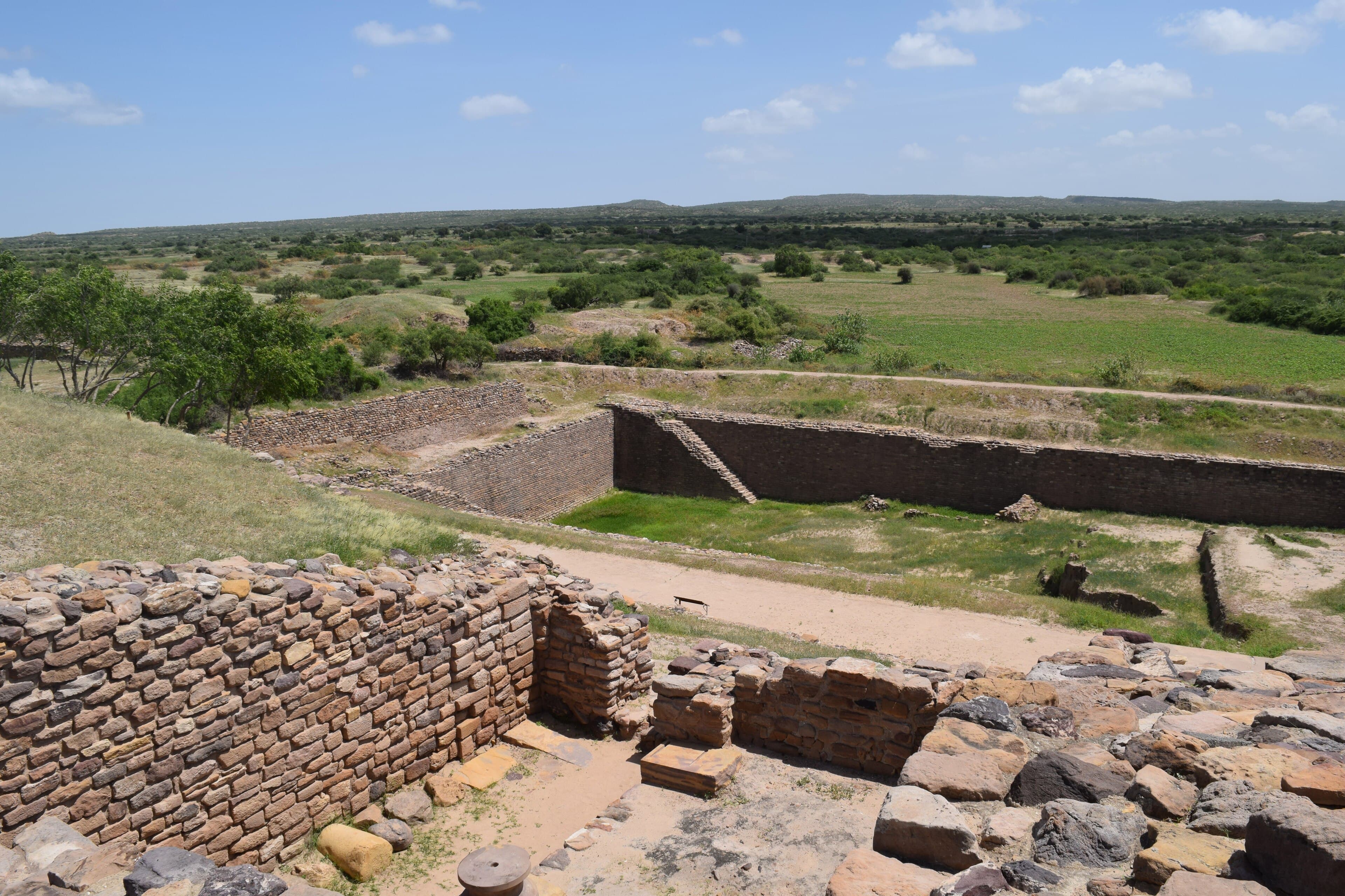
The true genius of Dholavira, however, lay beneath its streets and along its margins, where its builders waged a calculated war against drought. To live in the Kutch desert, the Harappans had to become masters of water. They dammed the seasonal Mansar and Manhar streams at multiple points, channeling the sudden, violent rushes of monsoon rainwater into a network of sixteen or more massive reservoirs that skirted the city walls. These reservoirs, some excavated deep into the living bedrock and others built of dressed stone, utilized the natural thirteen-meter slope of the terrain from the northeast to the southwest. Some of these stone-cut cisterns were gargantuan, reaching depths of seven meters and lengths of nearly eighty meters. In 2014, archaeologists began excavating a rectangular stepwell at the site that measured over seventy-three meters long and ten meters deep—three times the size of the famous Great Bath of Mohenjo-daro. This intricate system of channels, stone-cut troughs, dams, and settling tanks allowed Dholavira to collect, filter, and store every drop of fresh water that fell on the island, securing a reliable supply through years of severe drought.
This water-bound fortress was far from isolated; it was a wealthy, cosmopolitan hub of prehistoric global trade. Positioned along a strategic coastal route that linked the southern port of Lothal to Sindh, Punjab, and Sutkagan Dor on the distant Makran coast, Dholavira served as an entry point for goods flowing between the Indian subcontinent and Western Asia. Excavations have yielded a rich array of materials that speak to the city’s prosperity: delicate gold wire, ear studs, and globule beads; silver and copper ornaments; imported bronze vessels; and countless shell bangles. The workshops of Dholavira hummed with the production of terracotta pottery, including large black-slipped jars and painted black-on-red ware. Stone weights of various denominations suggest a highly regulated market, while master seal-cutters produced square stamp seals. The earliest of these seals featured only animal figures, representing early conventions of Indus seal-making before the introduction of writing.
The civic pride and administrative organization of Dholavira are crystallized in one of the most evocative archaeological discoveries of the twentieth century. In a side room of the city’s grand northern gateway, excavators found ten large, elegant symbols. Made from carefully shaped pieces of the white mineral gypsum, each symbol stood about thirty-seven centimeters high—roughly the size of the structural bricks in the nearby walls. They had originally been set into a massive wooden board, three meters in length, which hung above the gateway as a public sign. At some point in antiquity, the board fell forward and decayed, leaving the white gypsum letters preserved in the dirt in their original order. This "Dholavira Signboard" remains one of the longest continuous inscriptions in the undeciphered Indus script. Because of its monumental scale and highly public placement, the signboard is frequently cited by scholars as compelling evidence that the Indus script was not merely a private administrative shorthand for merchants, but a medium of public, widespread literacy. Nearby, archaeologists also recovered a four-sign inscription carved directly into sandstone—the first public inscription on stone found at any Harappan site.
Despite its geometric perfection, Dholavira was not immune to the violent forces of the earth or the shifting currents of history. Recent radiocarbon dating indicates that the site was occupied as early as 3500 BCE during a pre-Harappan phase, surviving a devastating earthquake around 2600 BCE before entering its golden age of monumental stone construction. But by 2100 BCE, the city began a long, slow decline. The regional climate grew increasingly arid, and the seasonal streams that fed the great stone reservoirs likely diminished. After a period of abandonment, a diminished population reoccupied the ruins, living in simpler dwellings until the city was finally deserted around 1800 BCE.
Among the final mysteries of Dholavira are its unique funerary monuments. Scattered across the site are hemispherical mud-brick structures built over large, rock-cut chambers, some designed in the shape of spoked wheels and others as wheels without spokes. These circular monuments contain rich grave goods, including copper mirrors, gold bangles, and steatite bead necklaces, yet they are almost entirely devoid of human skeletons. Only one grave yielded a skeleton. For archaeologists, these empty structures remain a profound puzzle—cenotaphs or memorials to those who died far from home, or perhaps early architectural precursors to the Buddhist stupas that would appear across India centuries later. Today, Dholavira stands as a UNESCO World Heritage Site, a monument to a society that engineered its own survival in one of the most hostile environments on Earth, leaving behind an indelible blueprint of human resilience written in stone.
Connected to
11 links to entries not yet ingested in the Library.